.png)
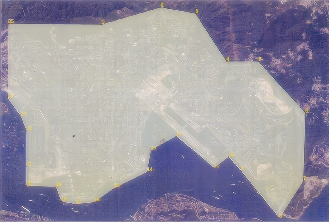
香港特别行政区政府规划署的 3D 规划设计系统的高分辨率、纹理化和 3D 网格模型采用倾斜摄影测量技术。
The high-resolution, textured, and 3D mesh model of the Hong Kong Special Administrative Region Government Planning Department’s 3D planning and design system adopts oblique photogrammetry technology.
我们提供以下服务:
i. 使用倾斜摄影测量技术在大约 48 平方公里的指定感兴趣区域 (AOI) 捕获建筑物和特征;
ii.对数据进行后处理,并以 OpenSceneGraph 二进制 (OSGB) 和 3DML 格式提供 3D 网格模型;
iii.对数据采集和后处理进行质量检查;
iv.提供指定AOI的数字表面模型(DSM)、正射影像、密集点云和原始数字航拍照片。
We provide the following services:
i. Using oblique photogrammetry technology to capture buildings and features in a designated area of interest (AOI), which is approximately 48 square kilometers;
ii.Post-processing the data and providing the 3D Mesh Models as OpenSceneGraph binary(OSGB)&3DML format;
iii.Performing quality check for the data capture and post processing;
iv.Providing the Digital Surface Model (DSM),orthophoto,dense point cloud and raw digital aerial photos of the specified AOI.
格式、分辨率和准确性
Format,Resolution and Accuracy
| Items | Format | Minimum
Required Resolution (GSD) |
Absolute Accuracy
(90%confidence) |
Relative Accuracy
(90%confidence) |
|||
| Horizontal | Vertical | Horizontal | Vertical | ||||
| 1 | 3D Mesh Models with
level-of-detail (LOD) |
OSGB &
3DML |
0.1m | 0.3m | 0.5m | 0.1m | 0.2m |
| 2 | Digital Surface Model (DSM) | TIFF | 0.1m | 0.3m | 0.5m | 0.1m | 0.2m |
| 3 | Orthophoto | TIFF & ECW | 0.1m | 0.3m | 0.1m | ||
| 4 | Dense Point Cloud with colour
information on each point |
LAS | 4 pts per
square meter |
0.5m | 0.5m | 0.2m | 0.2m |
| 5 | Raw Digital Aerial Photos | TIFF & JPEG | |||||
| 6 | ContextCapture project
file |
CCM | |||||
| 7 | Flight information with photo index | SHP | |||||
| 8 | Ground Control Point &Location Plan | XLS&PDF | |||||
| 9 | Index Plan for 3D Mesh ModelsTiles | SHP |
技术要求
1.所有坐标数据及地理参考均以香港 1980 方格坐标系为准。
2.没有云或云阴影应该会遮挡被拍摄的任何区域的细节。当烟雾、雾霾或任何其他情况会影响航拍照片的质量时,将不接受摄影。不允许云量超过 10%。
3.所有摄影测量目的都需要足够的水平和垂直控制测量。所有水平和垂直控制测量均应使用符合专业测量和摄影测量实践的程序和/或精度标准进行。
4.建立足够数量的控制点以满足准确性要求和质量控制要求是必要的。控制点应位于清晰可辨的特征或承建商识别的地点。控制点应为:
i.能清楚地看到天空;
ii.位于相对平坦的地形中,远离陡峭的地形;
ii. 位于已识别目标在工作任务期间极有可能保持不受干扰的区域。
5.控制点的精度要求水平(X、Y)不超过0.05m,垂直(Z)不超过0.15m。
6.2DSM应满足 +/-0.3m的绝对水平精度和 +/-0.5m的绝对垂直精度,置信度为 90%。3DSM应满足 +1-0.1m的相对水平精度和 +/-0.2m的相对垂直精度,置信度为 90%。
7.正射影像应采用色彩和色调平衡,以提供清晰的图像、足够的对比度、良好的辐射质量、自然的色彩和连续音调。正射影像应具有均衡的亮度和颜色直方图。
8.以通用的 LiDAR 数据交换格式 (.las) 提供密集的点云。密集点云应在每个点上都有颜色信息,并且密度至少为每平方米4点。
9.密集点云应满足 +/-0.5m 的绝对水平精度和 +/-0.5m 的绝对垂直精度,置信度为 90%。密集点云应满足 +/-0.2m 的相对水平精度和 +/-0.2m 的相对垂直精度,置信度为 90%。
10.提供原始数码航拍照片。
Technical Requirements
1.All coordinate data and geo-referencing shall refer to Hong Kong 1980 Grid coordinate system.
2.No cloud or cloud shadow should obscure detail on any area being photographed. The photography will not be accepted when smoke,haze or any other conditions would impair the quality of the aerial photographs.Cloud cover of more than 10% will not be permitted.
3.All photogrammetric surveying purposes require sufficient horizontal and vertical control measurements. All horizontal and vertical control measurements should be conducted using procedures and/or accuracy standards consistent with professional surveying and photogrammetry practices.
4.It is necessary to establish a sufficient number of control points to meet accuracy requirements and quality control requirements. The control points should be located on clear and identifiable features or points identified by the contractor. The control points should be:
i.Have a clear view of the sky;
ii.Located in a relatively level terrain,away from steep terrain;
ii.Located in areas where the identified target has a high probability of remaining undisturbed during the work assignment.
5.The accuracy requirements for control points shall not exceed 0.05m for horizontal(X and Y)and not exceed 0.15m for vertical (Z).
6.The 2DSM shall meet absolute horizontal accuracy of +/-0.3m and absolute vertical accuracy of+/-0.5m for a confidence level of 90%. The 3DSM shall meet relative horizontal accuracy of +1-0.1m and relative vertical accuracy of+/-0.2m for a confidence level of 90%.
7.Colour and tonal balancing shall be applied to the orthophoto to give clear image, sufficient contrast,good radiometric quality,natural colour
and continuous tone.The orthophoto shall have well balanced brightness and colour histogram.
8.Provide dense point clouds in a universal LiDAR data exchange format (.las). The Dense Point Cloud shall have colour information on each point and have a density of minimum 4 pts per square meter.
9.The Dense Point Cloud shall meet absolute horizontal accuracy of +/-0.5m and absolute vertical accuracy of+/-0.5m for a confidence level of 90%. The Dense Point Cloud shall meet relative horizontal accuracy of+/-0.2m and relative vertical accuracy of+/-0.2m for a confidence level of 90%.
10.Provide original digital aerial photographs.